 |
Worcestershire Megafinal
|
|
| Megafinal Home |
2016 Megafinal |
Parents' Information |
The venue | 2016 Entrants |
2015 Winners |
Worcestershire Chess |
|---|
2016 Worcestershire Megafinal will be held at the University of Worcester on Sunday 15 May 2016. Preliminary information and entry form will be published soon.
Welcome to the website for the Worcestershire Megafinal of UK Chess Challenge. The UK Chess Challenge is the largest chess tournament in the world with over school-aged 55,000 players. The Megafinal at Worcester has between 100 and 150 entrants from over 20 schools in Worcestershire. The national organisers use the Worcestershire boundary as it was in the late Victorian period when it was much larger than today. This is why schools in south Birmingham are playing in the Worcestershire Megafinal. The map below shows the boundaries of Worcestershire as they were in the late Victorian period. Unlike modern counties, there were detached parishes known as exclaves such as Dudley, Shipston, Evenlode and Blockley, Cutsdean, and Daylesford.
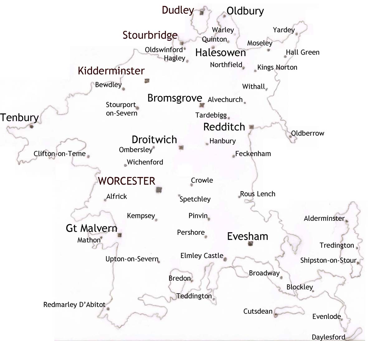 |
‹‹‹‹ Worcestershire in 1890Worcestershire boundariesEnglish counties were created by the Saxons and Worcestershire was the area controlled by the Hwicce peoples from Worcester. The Diocese of Worcester was created in 680 and the cathedral was a very powerful landowner in the Mercian Saxon kingdom and during the brief period when the Vikings overran Mercia. After Alfred the Great pushed the Vikings out of the West Midlands, the Saxons fortified Worcester and made it a regional capital. After the Norman conquest, King William needed the support of the Diocese of Worcester and Bishop Wulfstan retained his position. The Bishops of Worcester shared secular power with the Norman lords D'Abitot and Beauchamp and lands of these magnates formed the County of Worcester. Sometimes these magnates owned land separated from the bulk of their estates so creating exclaves, land entirely separated from the rest of county lands. As Britain industrialised, vagabonds often escaped justice by slipping across county boundaries and the authorities started to reduce the number of exclave parishes in 1844. Worcester gained Oldbury and Halesowen from Staffs, Clent from Shrops and Tardebigge from Warks at this time. As Birmingham grew, however, nearby Worcestershire villages fell under its influence. First was Quinton in 1909 and in 1911 Worcestershire lost Northfield, Moseley, Hall Green, and Yardley to Birmingham. The boundaries were further rationalised in 1931 so that old exclave parishes of Worcestershire were ceded to other counties. Cutsdean, Blockley, Evenlode, and Daylesford, were absorbed by Gloucestershire. Alderminster, Tredington amd Shipston-on-Stour became part of Warwickshire. In 1966, Worcestershire gained Warley including Smethwick, and Rowley Regis from Staffs, but lost Dudley. When the West Midlands was formed in 1974, Worcestershire lost Oldbury, Stourbridge Oldswinford, Cradley, Hagley and Halesowen. |
The 2015 Megafinal is planned with support from: Worcestershire Chess Association - for organising the megafinal and providing chess equipment; Mike Basman - for devising the competition and controlling the National Giga and Terafinals; and Delancey plc - for sponsoring national prizes, Giga and Tera finals.
| Internal links | Back to top | Worcestershire Chess | Megafinal home |
|---|---|---|---|
| External links | Delancey UK Chess Challenge | English Chess Federation | Worcs Jun Chess Acad |